


Preview
Identifier
20086263
Description
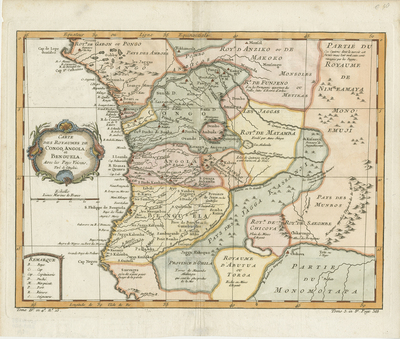
Colored map of southwestern African kingdoms. Features Congo, Angola, Benguela, and neighboring countries. Various tribes located and noted throughout. Decorative title cartouche at left side. Regions delineated by various colors. Border surrounding map includes scale. Scale key provided below title cartouche. Second map key provided in lower left corner. Landforms and waterways depicted throughout. Hachures included along coast of region. Double-paged, single-sided, horizontal map. 27 cm. x 37 cm. [Gift of Dr. Jack Franke]
Archival Date
1764
Collection Name
Maps of Africa
Collection Number
Acc. 2019-320
Language
French
Original Format
Maps
File Format
JPG
Rights
Rights held by The University of Texas at Arlington Libraries, Special Collections. Any use of content downloaded or printed from this page is limited to non-commercial personal or educational use, including fair use as directed by U.S. copyright laws. For more information or for reproduction requests, please contact UTA Special Collections by emailing spcoref@uta.edu.
License

This work is licensed under a Creative Commons Attribution-NonCommercial 4.0 International License
Subjects
Maps; Africa; Oceans; Cartouches (Graphic); Coastlines; Waterways