


Preview
Identifier
20086257
Description
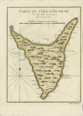
Anjouan antique map (also known as Ndzuwani or Nzwani). Copperplate engraved with hand coloring. Print includes hachures along coast of island and landforms within the island. Small red colored outposts/cities depicted along entire coast of island. Excellent condition of colored map that is vertical, single page, single sided. Platemark visible. 25 cm. x 20 cm. [Gift of Dr. Jack Franke]
Archival Date
1764
Collection Name
Maps of Africa
Collection Number
Acc. 2019-292
Language
French
Original Format
Maps
File Format
JPG
Rights
Rights held by The University of Texas at Arlington Libraries, Special Collections. Any use of content downloaded or printed from this page is limited to non-commercial personal or educational use, including fair use as directed by U.S. copyright laws. For more information or for reproduction requests, please contact UTA Special Collections by emailing spcoref@uta.edu.
License

This work is licensed under a Creative Commons Attribution-NonCommercial 4.0 International License
Subjects
Maps; Africa; Harbors; Islands; Coastlines