


Preview
Identifier
20086262
Description
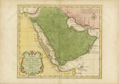
Colored map of Arabia, focusing along the coastline, featuring the Red Sea (left) and Persian Gulf (right). East coast of Africa generally included, with Egypt, Iraq, and the Persian Gulf. Most of Arabia, Africa, and neighboring Persia do not have detailed interiors. Large regions delineated by various colors. Decorative, floral, title cartouche located in bottom left corner. Border surrounding map includes scale. Scale key not provided. Compass rose provided within Persian region, with small fleur-de-lis motif located above compass. Note by cartographer on longitude and latitude coordinates featured above compass. Landforms not depicted, although few waterways are located. Stippling and shading used to indicate islands along regions' coast(s). Double-paged, single-sided, horizontal map on laid paper. Bound at centrefold on verso. Verso is blank. 27 cm. x 37 cm. [Gift of Dr. Jack Franke]
Archival Date
1740
Collection Name
Maps of Africa
Collection Number
Acc. 2019-319
Language
French
Original Format
Maps
File Format
JPG
Rights
Rights held by The University of Texas at Arlington Libraries, Special Collections. Any use of content downloaded or printed from this page is limited to non-commercial personal or educational use, including fair use as directed by U.S. copyright laws. For more information or for reproduction requests, please contact UTA Special Collections by emailing spcoref@uta.edu.
License

This work is licensed under a Creative Commons Attribution-NonCommercial 4.0 International License
Subjects
Maps; Africa; Oceans; Cartouches (Graphic); Coastlines