


Preview
Identifier
20086261
Description
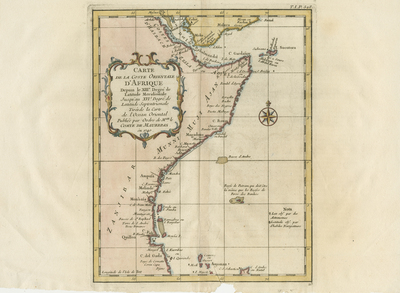
Colored map of eastern coast of Africa, begins at Costes D'Hasbach and concludes southwards within Zanguebar's coastal region. Includes surrounding islands. Interior widely left blank. Southern tip of neighboring region of Arabia is included generally. Ornate title cartouche featuring vegetation, located within blank interior to the left. Border surrounding map includes scale. Scale key is not provided. Compass rose included and located within Arabian Sea/Indian Ocean to the right, featuring small fleur-de-lis motif above. Light blue outlines used to indicate coast(s) off mainland and surrounding islands. Double-paged, single-sided, horizontal map on laid paper. Bound at centrefold on verso. Verso is blank. 25 cm. x 20 cm. [Gift of Dr. Jack Franke]
Archival Date
1740
Collection Name
Maps of Africa
Collection Number
Acc. 2019-318
Language
French
Original Format
Maps
File Format
JPG
Rights
Rights held by The University of Texas at Arlington Libraries, Special Collections. Any use of content downloaded or printed from this page is limited to non-commercial personal or educational use, including fair use as directed by U.S. copyright laws. For more information or for reproduction requests, please contact UTA Special Collections by emailing spcoref@uta.edu.
License

This work is licensed under a Creative Commons Attribution-NonCommercial 4.0 International License
Names
East Africa; Coastal regions; Indian Ocean; Zanzibar
Subjects
Maps; Africa; Oceans; Cartouches (Graphic); Coastlines