


Preview
Identifier
20086255
Description
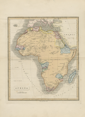
Colored map of Africa. Majority of map's interior is labeled as unexplored, reflecting knowledge of the continent during the time. Hachures are depicted along Africa's coast(s). Continent is outlined in orange while coastal regions are divided and distinguished by color. Surrounding regions of Arabia and Mediterranean are included, with city ports located. Title and scale are located in bottom left. Border surrounding the map includes scale. Alan Bell's "A New General Atlas, a Collection of Maps of the World & Various Quarters," published by Alan Bell & London, 1839. Publisher information located in bottom margin. Double paged, single sided, colored, and vertical map of Africa. Bound at centrefold on verso. Verso is blank. 36 cm. x 29 cm. [Gift of Dr. Jack Franke]
Archival Date
1839
Collection Name
Maps of Africa
Collection Number
Acc. 2019-326
Language
English
Original Format
Maps
File Format
JPG
Rights
Rights held by The University of Texas at Arlington Libraries, Special Collections. Any use of content downloaded or printed from this page is limited to non-commercial personal or educational use, including fair use as directed by U.S. copyright laws. For more information or for reproduction requests, please contact UTA Special Collections by emailing spcoref@uta.edu.
License

This work is licensed under a Creative Commons Attribution-NonCommercial 4.0 International License
Subjects
Maps; Africa; Harbors; Coastlines