


Preview
Identifier
20086260
Description
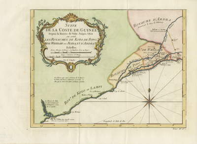
Colored map of Guinea coast, extending east of the Volta River (Ghana) including the Kingdoms of Koto, Popo, Whidah, and Ardra (the latter "destroyed by the King of Dahomey"), a.k.a. the Slave Coast, from the atlas of Prevost d'Exiles' collection of travel narratives, "Histoire Generale des Voyages." Interior left blank, with the information provided along the coast including several villages, towns, and coastal features. Decorative, floral, title cartouche located within top left portion, occupying most of map's interior. Border surrounding map includes scale. Scale key provided beneath title cartouche. Compass rose, located at bottom right with extending lines, features small fleur-de-lis motif above. Regions delineated by various colors. Landforms, waterways, and towns generally located. Hachures depicted off coast(s). Single-paged, single-sided, horizontal map on laid paper. Folds as issued. Without centrefold or binding. Map is copperplate engraved. 24 cm. x 37 cm. [Gift of Dr. Jack Franke]
Archival Date
1747
Collection Name
Maps of Africa
Collection Number
Acc. 2019-285
Language
French
Original Format
Maps
File Format
JPG
Rights
Rights held by The University of Texas at Arlington Libraries, Special Collections. Any use of content downloaded or printed from this page is limited to non-commercial personal or educational use, including fair use as directed by U.S. copyright laws. For more information or for reproduction requests, please contact UTA Special Collections by emailing spcoref@uta.edu.
License

This work is licensed under a Creative Commons Attribution-NonCommercial 4.0 International License
Subjects
Maps; Africa; Islands; Oceans; Cartouches (Graphic); Rivers; Coastlines