


Preview
Identifier
20088040
Description
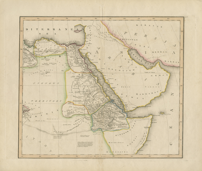
Uncolored map of Lower Nile Valley as being explored by the French and the British expeditions. Second map in set of four; double-paged, single-sided, horizontal. When the map was issued around 1825, European knowledge of Africa was still quite limited. While the coastal outline of the continent was well understood, and in some cases scientifically mapped, the map shows that much of the interior remained unknown territory. Surrounding regions of Persia, Arabia, and Palestine generally included with some caravan routes. Landforms and travel or caravan routes located in detail within Northeastern Africa. Regions distinguished by colored outlines. Border surrounding map includes scale. No key provided for outlined regions or scale. Hachures depicted off coast(s). Notes included throughout map describe terrain, climate, and seasonal patterns. Publisher information located at noted at bottom center of map. 89 cm. x 75 cm. [Gift of Dr. Jack Franke]
Archival Date
1825
Collection Name
Maps of Africa
Collection Number
Acc. 2019-152
Language
English
Original Format
Maps
File Format
JPG
Rights
Rights held by The University of Texas at Arlington Libraries, Special Collections. Any use of content downloaded or printed from this page is limited to non-commercial personal or educational use, including fair use as directed by U.S. copyright laws. For more information or for reproduction requests, please contact UTA Special Collections by emailing spcoref@uta.edu.
License

This work is licensed under a Creative Commons Attribution-NonCommercial 4.0 International License
Subjects
Maps; Africa; Colonies; Nile; Rivers; Mountains; Cartouches (Graphic); Expeditions & surveys