


Preview
Identifier
20086492
Description
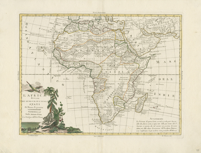
Colored map of Africa and its islands. Decorative and colored title cartouche located in lower left depicts local flora and fauna (generally) representing the continent. Neighboring regions of southern Mediterranean, Levant, Arabia, and Persia/Asia included. Africa is divided and outlined by color into colonial regions, with cartographic data based upon Janvier's maps, prepared for the French Academy of Science. This map was issued as part of Zatta's "Atlante Novissimo." Map is fairly accurate for the time period, although the source of the Nile is still incorrectly shown, rising from twin lakes of legendary Mountains of the Moon. The unknown parts of the continent are marked as such. Stellembos, modern day Stellenbosch, is the only inland place depicted within South Africa, as depictions are focused on the coastal areas near Cape of Good Hope. Within left corner, a warning is presented regarding how this map was made with the most recent information published, but that it may contain errors. Border surrounding map includes scale. No scale key or colonial possessions key provided. Locale of various tribes noted. Double-paged, single-sided, horizontal map. Bound at centrefold on verso. 30 cm. x 41 cm. [Gift of Dr. Jack Franke]
Archival Date
1776
Collection Name
Maps of Africa
Collection Number
Acc. 2019-168
Language
Italian
Original Format
Maps
File Format
JPG
Rights
Rights held by The University of Texas at Arlington Libraries, Special Collections. Any use of content downloaded or printed from this page is limited to non-commercial personal or educational use, including fair use as directed by U.S. copyright laws. For more information or for reproduction requests, please contact UTA Special Collections by emailing spcoref@uta.edu.
License

This work is licensed under a Creative Commons Attribution-NonCommercial 4.0 International License
Subjects
Maps; Africa; Mediterranean Sea; Nile; Rivers; Mountains; Cartouches (Graphic)