


Preview
Identifier
20086491
Description
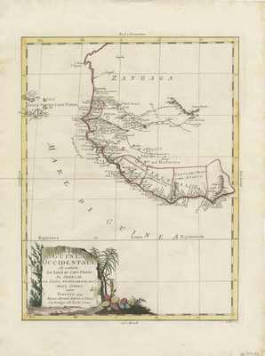
Uncolored map of West Africa, from C. Bianco d'Arguin and Caragol to the Gold Coast. Issued as part of Zatta's Atlante Novissimo. Cape Verde Island extends beyond border. Elaborate title cartouche surrounded with colorful vegetation located in lower left. Regions divided by red-colored outlines. Landforms and waterways within western coast included. Border surrounding map includes scale. No map key provided. Light hachures depicted off coast(s). Cardinal directions indicated within margins (in Italian). Double-paged, single-sided, vertical map bound on verso at centrefold. 41 cm. x 30 cm. [Gift of Dr. Jack Franke]
Archival Date
1794
Collection Name
Maps of Africa
Collection Number
Acc. 2019-165
Language
Italian
Original Format
Maps
File Format
JPG
Rights
Rights held by The University of Texas at Arlington Libraries, Special Collections. Any use of content downloaded or printed from this page is limited to non-commercial personal or educational use, including fair use as directed by U.S. copyright laws. For more information or for reproduction requests, please contact UTA Special Collections by emailing spcoref@uta.edu.
License

This work is licensed under a Creative Commons Attribution-NonCommercial 4.0 International License
Subjects
Maps; Africa; Islands; Cape Verde; Waterways; Coastlines