


Preview
Identifier
20086253
Description
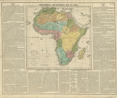
Full title: Africa: Drawn from the Best Authorities for the Illustration of Lavoisne's Genealogical, Historical, Chronological & Geographical Atlas. Original hand-colored map of Africa from the third American edition of the Atlas. This early 19th-century map features the old origin of the Nile River, emanating from two lakes in the 'Mountains of the Moon.' The map is surrounded on three sides by supplemental English text. Climate and Produce, Ancient State of Africa, Present State of Africa, Ancient State of Africa, European Settlements and Trade are headings listed in text areas surrounding the map. Different tribes shown throughout map. Border of map includes scale measured in miles. Key included in lower left corner next to title. Hachures seen off coast(s). Known regions delineated by color. Geographical forms and waterways depicted throughout map. Double-paged, single-sided map. 41 cm. x 51 cm. [Gift of Dr. Jack Franke]
Archival Date
1821
Collection Name
Maps of Africa
Collection Number
Acc. 2019-255
Language
English
Original Format
Maps
File Format
JPG
Rights
Rights held by The University of Texas at Arlington Libraries, Special Collections. Any use of content downloaded or printed from this page is limited to non-commercial personal or educational use, including fair use as directed by U.S. copyright laws. For more information or for reproduction requests, please contact UTA Special Collections by emailing spcoref@uta.edu.
License

This work is licensed under a Creative Commons Attribution-NonCommercial 4.0 International License
Subjects
Maps; Africa; Islands; Mountains; Colonies; Settlements