


Preview
Identifier
20086490
Description
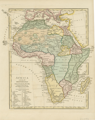
Colored map of Africa including neighboring regions of Arabia, southern Europe, Syria, and the Black Sea. Surrounding islands off mainland Africa including Madagascar extend beyond map's border and into page margins. Landforms and waterways depicted throughout map. Border includes scale. No key provided for scale. Regions delineated by different colors. Bottom left contains title and list of countries, known by English of the time, within Africa based on eastern, south-western, northern, and interior regions. Publisher information located below title (left). Single-paged, single-sided, vertical map without binding or centrefold. 28 cm. x 23 cm. [Gift of Dr. Jack Franke]
Archival Date
1809
Collection Name
Maps of Africa
Collection Number
Acc. 2019-296
Language
English
Original Format
Maps
File Format
JPG
Rights
Rights held by The University of Texas at Arlington Libraries, Special Collections. Any use of content downloaded or printed from this page is limited to non-commercial personal or educational use, including fair use as directed by U.S. copyright laws. For more information or for reproduction requests, please contact UTA Special Collections by emailing spcoref@uta.edu.
License

This work is licensed under a Creative Commons Attribution-NonCommercial 4.0 International License
Subjects
Maps; Africa; Islands