


Preview
Identifier
20086486
Description
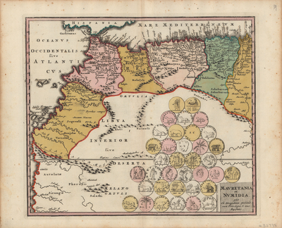
Colorful map of northwestern African coast, featuring geographical features as known to the ancients. Map begins from modern day Morocco, extending to Algeria and Tunisia. Modern day Senegal and Mauritania included, with interior of the map labeled as "Libya interior". Neighboring southern Spain featured for geographical context. Regions delineated with various colors. Interior uncolored and not as detailed, with general landforms and waterways located. Map features thirty-six medallions located within map's interior, relating to ancient coinage history and culture associated with the region. Landforms are depicted pictorially. Title cartouche located in bottom right corner. Hachures depicted off coast(s). Single-paged, single-sided, horizontal map on laid paper. Bound on verso at centrefold. 41 cm. x 33 cm. [Gift of Dr. Jack Franke]
Archival Date
1718
Collection Name
Maps of Africa
Collection Number
Acc. 2019-350
Language
Latin
Original Format
Maps
File Format
JPG
Rights
Rights held by The University of Texas at Arlington Libraries, Special Collections. Any use of content downloaded or printed from this page is limited to non-commercial personal or educational use, including fair use as directed by U.S. copyright laws. For more information or for reproduction requests, please contact UTA Special Collections by emailing spcoref@uta.edu.
License

This work is licensed under a Creative Commons Attribution-NonCommercial 4.0 International License
Subjects
Maps; Africa; Waterways; Mediterranean Sea; Coastlines; Morocco; Tunisia; Senegal; Cartouches (Graphic)