


Preview
Identifier
20086483
Description
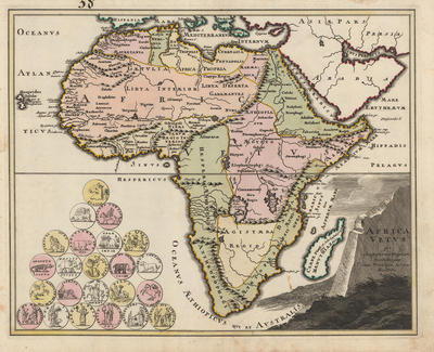
Colorful and decorative map of ancient Africa, with geographical features as known to the ancients. Neighboring regions of southern Europe, Arabia, and Persia included. Features twenty-three decorated medallions, located in bottom left corner, with imagery deriving from ancient coinage history and culture. Title cartouche located in bottom right corner, displayed atop a rocky outcrop, presumably indicating bedrock of region or ancient superficial deposits relating to archaeology. Landforms printed prominently and located. Regions delineated by various colors. Hachures printed to indicate coast(s). Single-paged, single-sided, horizontal map on laid paper. 33 cm. x 41 cm. [Gift of Dr. Jack Franke]
Archival Date
1720
Collection Name
Maps of Africa
Collection Number
Acc. 2019-215
Language
Latin
Original Format
Maps
File Format
JPG
Rights
Rights held by The University of Texas at Arlington Libraries, Special Collections. Any use of content downloaded or printed from this page is limited to non-commercial personal or educational use, including fair use as directed by U.S. copyright laws. For more information or for reproduction requests, please contact UTA Special Collections by emailing spcoref@uta.edu.
License

This work is licensed under a Creative Commons Attribution-NonCommercial 4.0 International License
Subjects
Maps; Africa; Cartouches (Graphic); Historical geography; Coins; Illustrations