


Preview
Identifier
20086485
Description
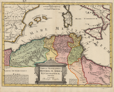
Colored map of northern African coast. Map title translates to, "Map history of the Church in Africa." Travel routes are located throughout map. Decorative title cartouche, located at bottom center, resembles ancient Greco-Roman architecture. Cartographer includes two additional texts, each located on either side of title cartouche. Neighboring regions of southern Spain, its islands, and southern Italy are included with considerable detail. Regions within Africa delineated by various colors. Border surrounding map includes scale. Scale key, located near Corsica at top center, provides two different scale measurements. Landforms and waterways located throughout. Hachures depicted off coast(s). Single-paged, single-sided, horizontal map on laid paper. Verso is blank. Without binding on verso. Centrefold as issued. 33 cm. x 44 cm. [Gift of Dr. Jack Franke]
Archival Date
1719
Collection Name
Maps of Africa
Collection Number
Acc. 2019-218
Language
Latin
Original Format
Maps
File Format
JPG
Rights
Rights held by The University of Texas at Arlington Libraries, Special Collections. Any use of content downloaded or printed from this page is limited to non-commercial personal or educational use, including fair use as directed by U.S. copyright laws. For more information or for reproduction requests, please contact UTA Special Collections by emailing spcoref@uta.edu.
License

This work is licensed under a Creative Commons Attribution-NonCommercial 4.0 International License
Subjects
Maps; Africa; Waterways; Mediterranean Sea; Coastlines; Islands; Cartouches (Graphic)