


Preview
Identifier
20086484
Description
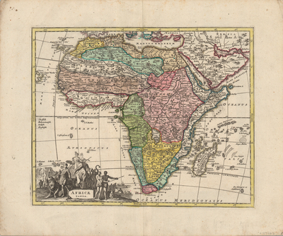
Colorful rendition of Weigel's modern map of Africa and its islands. Some geographic information shown accurately, while others still based on Ptolemaic maps, such as the source of the Nile deriving from Lakes Zaire and Zaflan. Neighboring regions of southern Europe, Arabia, and Persia included. Decorative title cartouche is located in bottom left corner. Features light skinned individuals, robed and wearing a headdress, seated atop an elephant, surrounded by both dark and light skinned peoples (some clothed more than others), with a mother and child observing. Animals native to the region are included within the scene, among a seascape of ships and mountains in the background. Small motifs indicating mosques, located throughout Africa and Arabia. Locale of various ethnic groups noted. Landforms and waterways are located throughout Africa, Arabia, and Persia. Regions delineated by various colors, including the surrounding countries featured. Border surrounding map includes scale. Scale key not provided. Hachures depicted off coast(s). Double-paged, single-sided, horizontal map on laid paper. Bound at centrefold on verso. Verso is blank. 36 cm. x 28 cm. [Gift of Dr. Jack Franke]
Archival Date
1720
Collection Name
Maps of Africa
Collection Number
Acc. 2019-153
Language
Latin
Original Format
Maps
File Format
JPG
Rights
Rights held by The University of Texas at Arlington Libraries, Special Collections. Any use of content downloaded or printed from this page is limited to non-commercial personal or educational use, including fair use as directed by U.S. copyright laws. For more information or for reproduction requests, please contact UTA Special Collections by emailing spcoref@uta.edu.
License

This work is licensed under a Creative Commons Attribution-NonCommercial 4.0 International License
Subjects
Maps; Africa; Nile; Lakes; Cartouches (Graphic); Illustrations