


Preview
Identifier
20086481
Description
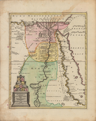
Colored map of Egypt and its surroundings, with decorative Greco-Roman inspired title cartouche. Features eleven medallions based on ancient coinage history and culture associated with the region, serving as a pediment above the title cartouche. Map shows path of the Nile River, extending from the Mediterranean Sea and into to the ancient city of Meroë within modern Sudan. Includes neighboring regions of Arabia and Levant region generally, along with the Red Sea extending south into the Astaboras River. Different regions of Egypt delineated by various colors. Map key not provided. Landforms and waterways located throughout. Border surrounding map includes scale. Scale key not provided. Hachures depicted off coast(s). Single-paged, single-sided, vertical map on laid paper. Verso is blank. Verso without binding. Centrefold as issued. 39 cm.x 31 cm. [Gift of Dr. Jack Franke]
Archival Date
1718
Collection Name
Maps of Africa
Collection Number
Acc. 2019-217
Language
Latin
Original Format
Maps
File Format
JPG
Rights
Rights held by The University of Texas at Arlington Libraries, Special Collections. Any use of content downloaded or printed from this page is limited to non-commercial personal or educational use, including fair use as directed by U.S. copyright laws. For more information or for reproduction requests, please contact UTA Special Collections by emailing spcoref@uta.edu.
License

This work is licensed under a Creative Commons Attribution-NonCommercial 4.0 International License
Subjects
Maps; Africa; Egypt; Cartouches (Graphic); Mediterranean Sea; Nile; Rivers; Waterways