


Preview
Identifier
20086480
Description
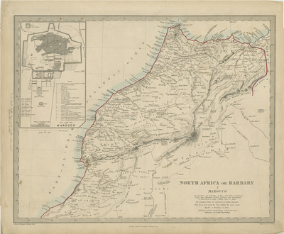
Sheet 1 Map of northern Africa showing the Kingdom of Morocco with inset of the city of Morocco (Marrakesh) in upper left. List of gates and mosques within city, located beneath city plan, within inset. Scale for plan included. Additional scale for map oriented vertically within left margin of map. Publisher information located within bottom margin. Title of map located in bottom right of map, accompanied with small legend of useful knowledge for traversing northern Africa, notes include heights of mountains measured in yards, few Arabic word translations into English, a note on trade routes, and notes where principal tribes are located. Landforms and trade routes included within map. Light blue used to indicate coast of region, vibrant red used to indicate surrounding shoreline. Border of map simple in design with scale measurements. Single-paged, single-sided, horizontal map. Verso blank. 32 cm. x 41 cm. [Gift of Dr. Jack Franke]
Archival Date
1844
Collection Name
Maps of Africa
Collection Number
Acc. 2019-401
Language
English
Original Format
Maps
File Format
JPG
Rights
Rights held by The University of Texas at Arlington Libraries, Special Collections. Any use of content downloaded or printed from this page is limited to non-commercial personal or educational use, including fair use as directed by U.S. copyright laws. For more information or for reproduction requests, please contact UTA Special Collections by emailing spcoref@uta.edu.
License

This work is licensed under a Creative Commons Attribution-NonCommercial 4.0 International License
Subjects
Maps; Africa; Mosques; Mountains; Marrakech (Morocco)