


Preview
Identifier
20086440
Description
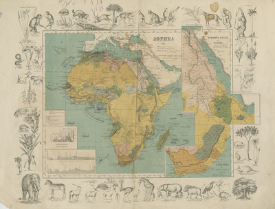
Russian atlas map of Africa, published by Spammer, with insets showing South Africa and Ethiopia. The map itself is surrounded by uncolored woodcut engravings of the various animals and flora that you would encounter around the region. With tables explaining colored symbols, colonized regions, topography and mileage scale. Double paged, bound on backside. 28 cm. x 35 cm. [Gift of Dr. Jack Franke]
Archival Date
1871
Collection Name
Maps of Africa
Collection Number
Acc. 2019-324
Language
Russian
Original Format
Maps
File Format
JPG
Rights
Rights held by The University of Texas at Arlington Libraries, Special Collections. Any use of content downloaded or printed from this page is limited to non-commercial personal or educational use, including fair use as directed by U.S. copyright laws. For more information or for reproduction requests, please contact UTA Special Collections by emailing spcoref@uta.edu.
License

This work is licensed under a Creative Commons Attribution-NonCommercial 4.0 International License
Subjects
Maps; Africa; Ethiopia; South Africa; Illustrations; Borders (Ornamental)