


Preview
Identifier
20086478
Description
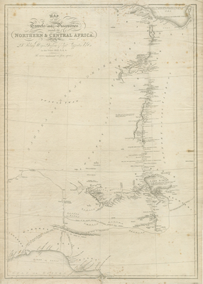
Uncolored map of North and Central Africa depicting parts of Libya, Chad, Nigeria, and Benin, as well as several other African nations; no 'international' borders are depicted. The map illustrates the expedition led by Walter Oudney, Hugh Clapperton, and Dixon Denham in detail. It traces their route from the Mediterranean Sea, close to the city of Tripoli, south through the Sahara to Lake Chad (Lake Tchad), and west from Lake Chad to Sackatoo. Many notes and way points are marked along their route, allowing the viewer to trace an follow their journey. Hachures depicted along coast(s). Landforms located within region. Cursive cartouche in upper right. Border surrounding map includes scale. Single-paged, single-sided, vertical map.
Archival Date
1826
Collection Name
Maps of Africa
Collection Number
Acc. 2019-397
Language
English
Original Format
Maps
File Format
JPG
Rights
Rights held by The University of Texas at Arlington Libraries, Special Collections. Any use of content downloaded or printed from this page is limited to non-commercial personal or educational use, including fair use as directed by U.S. copyright laws. For more information or for reproduction requests, please contact UTA Special Collections by emailing spcoref@uta.edu.
License

This work is licensed under a Creative Commons Attribution-NonCommercial 4.0 International License
Subjects
Maps; Africa; Cartouches (Graphic); Deserts; Expeditions; Mediterranean Sea; Sahara; Lakes; Lake Chad; Nigeria; Libya