


Preview
Identifier
20086468
Description
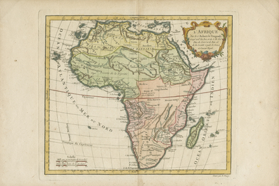
Colored map of Africa from, "Nouvel Atlas Portatif destine principalement sur l'Etude de la Geographie par le S.Robert Vaugondy, a Paris 1778, de la Societe Royale des Sciences et Belles Lettres de Nancy et Conseur Royal." Map spans from Mediterranean Sea and Arabia, to north of Cape of Good Hope in southern Africa. Islands surrounding Africa, including Madagascar, depicted. Border surrounding map includes scale. Scale key located in lower left, including two measurements of time and distance. Colorful title cartouche in upper right corner. Regions delineated with filled coloring and outlines. Hachures depicted along coast(s). Landforms and waterways located throughout continent. Tribes and regions noted throughout. Engraver listed in bottom right corner, outside of map border. Double-paged, single-sided, horizontal map. 24 cm. x 28 cm. [Gift of Dr. Jack Franke]
Archival Date
1778
Collection Name
Maps of Africa
Collection Number
Acc. 2019-205
Language
French
Original Format
Maps
File Format
JPG
Rights
Rights held by The University of Texas at Arlington Libraries, Special Collections. Any use of content downloaded or printed from this page is limited to non-commercial personal or educational use, including fair use as directed by U.S. copyright laws. For more information or for reproduction requests, please contact UTA Special Collections by emailing spcoref@uta.edu.
License

This work is licensed under a Creative Commons Attribution-NonCommercial 4.0 International License
Subjects
Maps; Africa; Islands; Oceans; Cartouches (Graphic)