


Preview
Identifier
20086469
Description
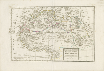
Uncolored map of northern Africa engraved by E. Dussy. Reviewed and corrected by Delamarche his successor. Giles and Didier Robert de Vaugondy, father and son, were famous 18th-century cartographers, descendants of the also cartographer Nicolas Sanson from whom they inherited much of their cartographic material. Cape Verde Islands extend past border surrounding the print. Border around map includes scale. Scale located in lower left. Title located in bottom right. Regions delineated by colored outlines. Very light hachures seen off coast(s). Landforms and waterways depicted throughout region. Various tribes noted within. Double-paged, single-sided, horizontal map, bound on verso at centrefold. 26 cm. x 38 cm. [Gift of Dr. Jack Franke]
Archival Date
1800
Collection Name
Maps of Africa
Collection Number
Acc. 2019-372
Language
French
Original Format
Maps
File Format
JPG
Rights
Rights held by The University of Texas at Arlington Libraries, Special Collections. Any use of content downloaded or printed from this page is limited to non-commercial personal or educational use, including fair use as directed by U.S. copyright laws. For more information or for reproduction requests, please contact UTA Special Collections by emailing spcoref@uta.edu.
License

This work is licensed under a Creative Commons Attribution-NonCommercial 4.0 International License
Subjects
Maps; Africa; Ethiopia; Egypt; Nubia; Guinea; Nigeria; Rivers