


Preview
Identifier
20086466
Description
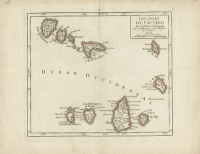
Cape Verde islands - Cabo Verde - Santo Antão - São Vicente - Santa Luzia - São Nicolau - Sal - Boa Vista - Maio - Santiago - Fogo - Brava. Striking example of De Vaugondy's map of the Cape Verde Islands, from his "Atlas Portatif, Universel et Militaire...," first published in Paris in 1748. Horizontal map, double paged, single sided, bound on verso centerfold. Uncolored with red outlines and hachures to indicate coasts around each island. Visible platemark and verso is blank. 18 cm. x 18 cm. [Gift of Dr. Jack Franke]
Archival Date
1749
Collection Name
Maps of Africa
Collection Number
Acc. 2019-295
Language
French
Original Format
Maps
File Format
JPG
Rights
Rights held by The University of Texas at Arlington Libraries, Special Collections. Any use of content downloaded or printed from this page is limited to non-commercial personal or educational use, including fair use as directed by U.S. copyright laws. For more information or for reproduction requests, please contact UTA Special Collections by emailing spcoref@uta.edu.
License

This work is licensed under a Creative Commons Attribution-NonCommercial 4.0 International License
Subjects
Maps; Africa; Islands; Cape Verde; Oceans