


Preview
Identifier
20086412
Description
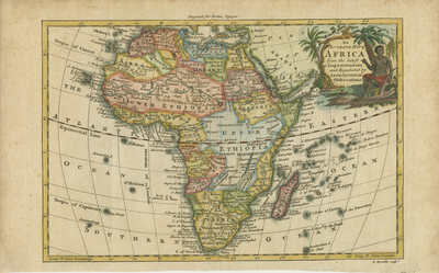
Colored map of Africa and its surrounding islands. Decorative title cartouche in upper right corner depicts local inhabitant seated on a crocodile, surrounded by lush vegetation. Map slightly includes neighboring regions of southern Mediterranean, Levant region, and Arabia for geographical context. Regions delineated by various colors. Landforms and waterways depicted throughout. Border surrounding map includes scale. Scale key not provided. Hachures depicted off coast(s). Locale of various tribes noted. Engraver listed at top center of page. Single-paged, single-sided, horizontal map. Without centrefold or binding. 45 cm. x 70 cm. [Gift of Dr. Jack Franke]
Archival Date
1768
Collection Name
Maps of Africa
Collection Number
Acc. 2019-290
Language
English
Original Format
Maps
File Format
JPG
Rights
Rights held by The University of Texas at Arlington Libraries, Special Collections. Any use of content downloaded or printed from this page is limited to non-commercial personal or educational use, including fair use as directed by U.S. copyright laws. For more information or for reproduction requests, please contact UTA Special Collections by emailing spcoref@uta.edu.
License

This work is licensed under a Creative Commons Attribution-NonCommercial 4.0 International License
Subjects
Maps; Africa; Islands; Oceans; Waterways; Cartouches (Graphic)