


Preview
Identifier
20086454
Description
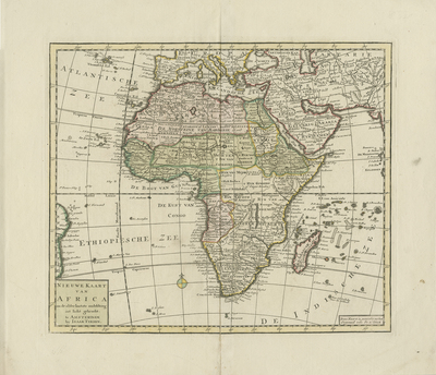
Colored, copper engraved map of Africa and its surrounding islands by Isaac Tirion published around 1750. Neighboring regions of southern Europe, Arabia, Persia, Tartary (historic term for north, central, and eastern Asia), and reference to the Mongol region are included with detail. Minor reference to South America provided in the west, for geographic context to Africa's location. Landforms and waterways depicted throughout. Small compass rose provided, left of southern Africa. Title cartouche located in bottom left corner. Locale of various tribes noted. Regions outlined and shaded by various colors. Map key not provided. Border surrounding map includes scale. Scale key not provided. Hachures depicted off coast(s). Double-paged, single-sided, horizontal map on laid paper. Centrefold bound at verso. Verso is blank. 28 cm. x 32 cm. [Gift of Dr. Jack Franke]
Archival Date
1750
Collection Name
Maps of Africa
Collection Number
Acc. 2019-199
Language
Dutch
Original Format
Maps
File Format
JPG
Rights
Rights held by The University of Texas at Arlington Libraries, Special Collections. Any use of content downloaded or printed from this page is limited to non-commercial personal or educational use, including fair use as directed by U.S. copyright laws. For more information or for reproduction requests, please contact UTA Special Collections by emailing spcoref@uta.edu.
License

This work is licensed under a Creative Commons Attribution-NonCommercial 4.0 International License
Subjects
Maps; Africa; Waterways; Oceans; Islands; Mountains; Cartouches (Graphic)