


Preview
Identifier
20086453
Description
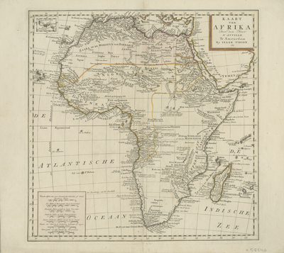
Uncolored map of Africa, based on work of J. B. B. D'Anville, one of the world's most influential mapmakers during the mid 18th century. Map provides details over colonial strongholds near slave trading regions of the Gambia and Senegal Rivers, the Portuguese colonies of Angola and Congo, and Dutch South African interests. Map includes regions of Spain, Italy, the Mediterranean Sea, and Arabia generally. Source of the Nile River are two mythical lakes near the Mountains of the Moon. Border surrounding map includes scale. Scale key provided in lower left corner, with with seven different scale measurements. Title cartouche located in top right corner. Inset included in top left corner, with its own scale border, featuring Azores islands near Portugal. Some regions within continent outlined by varying colors. Locale of various tribes noted. Landforms and waterways depicted throughout. Double-paged, single-sided map. 46 cm. x 36 cm. [Gift of Dr. Jack Franke]
Archival Date
1763
Collection Name
Maps of Africa
Collection Number
Acc. 2019-331
Language
Dutch
Original Format
Maps
File Format
JPG
Rights
Rights held by The University of Texas at Arlington Libraries, Special Collections. Any use of content downloaded or printed from this page is limited to non-commercial personal or educational use, including fair use as directed by U.S. copyright laws. For more information or for reproduction requests, please contact UTA Special Collections by emailing spcoref@uta.edu.
License

This work is licensed under a Creative Commons Attribution-NonCommercial 4.0 International License
Subjects
Maps; Africa; Nile; Rivers; Lakes; Gambia; Senegal; Colonies; Cartouches (Graphic)