


Preview
Identifier
20086433
Description
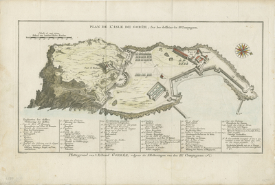
A plan of the island and fort in Island of Gorée, off the Africa mainland coast of Guinea. This plan is of a compound from where slaves were shipped to the Americas. Scale key in top left corner. Additional map key provided along bottom margin, indicating layout of compound and associated features. Area seven is where slaves were housed, near fort of St. Francois. Area fifteen is a proposition for future expansion of the fort. Area forty is the compound of free "Negroes." Compass rose printed in top right corner. Landforms and transportation routes depicted throughout. Jan van Schley is the engraver of the maps (by J. N. Bellin) and views in the Dutch edition of A.F. Prévost d' Exile's "Histoire Géneral des Voyages." Single-paged, single-sided, horizontal map. Without binding or centrefold. 26 cm. x 30 cm. [Gift of Dr. Jack Franke]
Archival Date
1760
Collection Name
Maps of Africa
Collection Number
Acc. 2019-176
Language
French;Dutch
Original Format
Maps
File Format
JPG
Rights
Rights held by The University of Texas at Arlington Libraries, Special Collections. Any use of content downloaded or printed from this page is limited to non-commercial personal or educational use, including fair use as directed by U.S. copyright laws. For more information or for reproduction requests, please contact UTA Special Collections by emailing spcoref@uta.edu.
License

This work is licensed under a Creative Commons Attribution-NonCommercial 4.0 International License
Subjects
Maps; Africa; Island of Gorée; Islands; Mountains; Slave trade; Plans; Forts & fortifications; Coastlines