


Preview
Identifier
20086451
Description
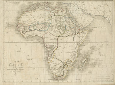
Large folio, uncolored map of Africa from the book "Atlas pour servir à l'intelligence de l'histoire générale des voyages." Central Africa largely unexplored. Surrounding regions of Arabia, Mediterranean, and Asia included. Hachures depicted off coast and landforms depicted throughout continent. Colored outlines indicate different regions within continent. No key provided. Cursive cartouche located in bottom left. Scale is located in bottom right. Border surrounding map includes scale. Single-paged, single-sided, horizontal map without binding. 43 cm. x 57 cm [Gift of Dr. Jack Franke]
Archival Date
1821
Collection Name
Maps of Africa
Collection Number
Acc. 2019-188
Language
French
Original Format
Maps
File Format
JPG
Rights
Rights held by The University of Texas at Arlington Libraries, Special Collections. Any use of content downloaded or printed from this page is limited to non-commercial personal or educational use, including fair use as directed by U.S. copyright laws. For more information or for reproduction requests, please contact UTA Special Collections by emailing spcoref@uta.edu.
License

This work is licensed under a Creative Commons Attribution-NonCommercial 4.0 International License
Subjects
Maps; Africa; Oceans; Islands; Deserts; Cartouches (Graphic)