


Preview
Identifier
20086414
Description
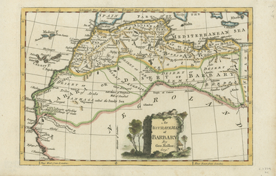
Copper engraved and colored map of the northwestern Africa coast published in Fenning's "A New System of Geography." Map focuses on the regions of Barbary Coast, and the Sahara. Little to no detail provided within region of "Negroland." Decorative title cartouche located at bottom center of map, below "Negroland," featuring landscape scene with local house and surrounding vegetation. Border surrounding map includes scale. Scale key not provided. Hachures depicted off coast(s). Regions outlined by various colors. Landforms and waterways depicted throughout. Cartographer has notes on locations of resources and over the climate within certain regions. Locale of various empires and republics noted. Single-paged, single-sided, horizontal map. 20 cm. x 30 cm. [Gift of Dr. Jack Franke]
Archival Date
1760
Collection Name
Maps of Africa
Collection Number
Acc. 2019-227
Language
English
Original Format
Maps
File Format
JPG
Rights
Rights held by The University of Texas at Arlington Libraries, Special Collections. Any use of content downloaded or printed from this page is limited to non-commercial personal or educational use, including fair use as directed by U.S. copyright laws. For more information or for reproduction requests, please contact UTA Special Collections by emailing spcoref@uta.edu.
License

This work is licensed under a Creative Commons Attribution-NonCommercial 4.0 International License
Subjects
Maps; Africa; Deserts; Coastlines; Cartouches (Graphic)