


Preview
Identifier
20086413
Description
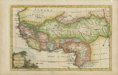
Colored, copper engraved map of West Africa published in Fenning's "A New System of Geography." Source of Nile originates from the fictitious "Mountains of the Moon." Map focus on regions of the Guinea coast and "Negroland." Cartographer lists resources found within different regions of west coast Africa. Locale of several kingdoms noted throughout map. Landforms and waterways located throughout. Border surrounding map includes scale. Scale key not provided. Decorative title cartouche, located in bottom left corner, features outdoor scene of wildlife. Regions delineated by shades of various colors. Hachures depicted off coast(s). Single-paged, single-sided, horizontal map on laid paper. Without binding or centrefold. 20 cm. x 30 cm. [Gift of Dr. Jack Franke]
Archival Date
1760
Collection Name
Maps of Africa
Collection Number
Acc. 2019-226
Language
English
Original Format
Maps
File Format
JPG
Rights
Rights held by The University of Texas at Arlington Libraries, Special Collections. Any use of content downloaded or printed from this page is limited to non-commercial personal or educational use, including fair use as directed by U.S. copyright laws. For more information or for reproduction requests, please contact UTA Special Collections by emailing spcoref@uta.edu.
License

This work is licensed under a Creative Commons Attribution-NonCommercial 4.0 International License
Subjects
Maps; Africa; Mountains; Oceans; Waterways; Cartouches (Graphic); Guinea