


Preview
Identifier
20086473
Description
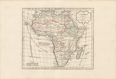
Uncolored map of Africa by Robert de Vaugondy, revised and published by Delamarche. Title cartouche located in top right. Surrounding border of map includes scale. Scale key is located in bottom left. Light hachures depicted off coast(s). Regions delineated by varied colored outlines. Map features mentions of certain tribes within continent. Various landforms and waterways located throughout map. Double-paged, single-sided, horizontal map. Bound on verso at centrefold. 24 cm. x 28 cm. [Gift of Dr. Jack Franke]
Archival Date
1806
Collection Name
Maps of Africa
Collection Number
Acc. 2019-373
Language
French
Original Format
Maps
File Format
JPG
Rights
Rights held by The University of Texas at Arlington Libraries, Special Collections. Any use of content downloaded or printed from this page is limited to non-commercial personal or educational use, including fair use as directed by U.S. copyright laws. For more information or for reproduction requests, please contact UTA Special Collections by emailing spcoref@uta.edu.
License

This work is licensed under a Creative Commons Attribution-NonCommercial 4.0 International License
Subjects
Maps; Africa; Cartouches (Graphic); Deserts; Waterways; Islands; Madagascar; Colonies; Congo (Democratic Republic)