


Preview
Identifier
20086411
Description
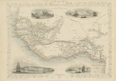
Drawn and engraved by John Rapkin for, "The Illustrated Atlas and Modern History of the World" by Montgomery Martin. Published in London, 1851, by The London Printing and Publishing Company. A map of West Africa illustrated with vignette engravings of Christiansborg (known as Osu Castle today), Bakel, Cape Coast Castle, and Sierra Leone. Map presents Senegal, Gambia, Togo, Guinea, Liberia, Sierra Leone, Nigeria, Benin, and Ghana with their landforms respectively. Cartographer delineated each region with original hand colored outline. Map is uncolored with simply decorated border around map. Scale and title located at top center. Publisher information along bottom margin. An example of the preferred Montgomery Martin edition without the centrefold. Single-page, single-sided, horizontal map. 26 cm. x 37 cm. [Gift of Dr. Jack Franke]
Archival Date
1850
Collection Name
Maps of Africa
Collection Number
Acc. 2019-233
Language
English
Original Format
Maps
File Format
JPG
Rights
Rights held by The University of Texas at Arlington Libraries, Special Collections. Any use of content downloaded or printed from this page is limited to non-commercial personal or educational use, including fair use as directed by U.S. copyright laws. For more information or for reproduction requests, please contact UTA Special Collections by emailing spcoref@uta.edu.
License

This work is licensed under a Creative Commons Attribution-NonCommercial 4.0 International License
Subjects
Maps; Africa; Vignettes; Illustrations; Borders (Ornamental)