


Preview
Identifier
20086410
Description
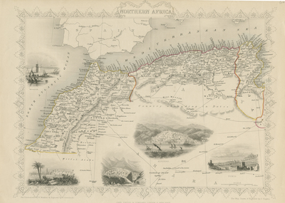
Steel engraved map of Northwestern Africa, with decorative border surrounding map and title located at top center. Uncolored vignettes of Mogador, Morocco, Constantine, Algiers and Tunis included. Mountain ranges and caravan routes featured throughout map. Hachures are used to indicate coastal regions. Scale in miles is located at bottom right. Single-paged, single-sided, horizontal map. 26 cm. x 36 cm. [Gift of Dr. Jack Franke]
Archival Date
1850
Collection Name
Maps of Africa
Collection Number
Acc. 2019-232
Language
English
Original Format
Maps
File Format
JPG
Rights
Rights held by The University of Texas at Arlington Libraries, Special Collections. Any use of content downloaded or printed from this page is limited to non-commercial personal or educational use, including fair use as directed by U.S. copyright laws. For more information or for reproduction requests, please contact UTA Special Collections by emailing spcoref@uta.edu.
License

This work is licensed under a Creative Commons Attribution-NonCommercial 4.0 International License
Subjects
Maps; Africa; Mountains; Vignettes; Illustrations; Borders (Ornamental)