


Preview
Identifier
20086409
Description
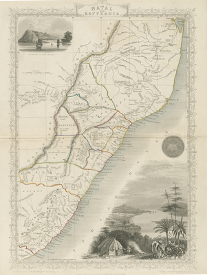
Drawn and engraved by John Rapkin for "The Illustrated Atlas and Modern History of the World," by Martin Montgomery. A map of the eastern region of South Africa with the Orange River Sovereignty to the west. Covers the Eastern cape area and northwards up to present-day Maputo in Mozambique. Uncolored map with simple design of decorative border. Title is located at top center. Includes two illustrated vignette engravings of Port Natal and Seal of Natal depiction. In lower right vignette, a small settlement is seen in Port Natal with a small view showing the town of Durban. At top left the entrance of Port Natal is depicted. The seal of Natal, made by the British, is located at right side of map. Tribal regions (distinguished by color outlines) with minor references to region's terrain and coastal cities are included within the map. Double-paged, single-sided, vertical map. Bound at centrefold on verso. 26 cm. x 37 cm. [Gift of Dr. Jack Franke]
Archival Date
1855
Collection Name
Maps of Africa
Collection Number
Acc. 2019-235
Language
English
Original Format
Maps
File Format
JPG
Rights
Rights held by The University of Texas at Arlington Libraries, Special Collections. Any use of content downloaded or printed from this page is limited to non-commercial personal or educational use, including fair use as directed by U.S. copyright laws. For more information or for reproduction requests, please contact UTA Special Collections by emailing spcoref@uta.edu.
License

This work is licensed under a Creative Commons Attribution-NonCommercial 4.0 International License
Subjects
Maps; Africa; Mountains; Cartouches (Graphic); Vignettes; Ports; Illustrations; Borders (Ornamental)