


Preview
Identifier
20086408
Description
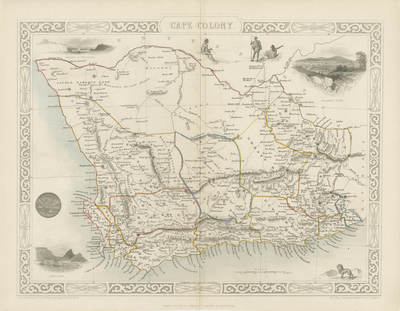
Drawn and engraved by John Rapkin for, "The Illustrated Atlas and Modern History of the World" by Montgomery Martin. Published in London, 1851, by The London Printing and Publishing Company. Uncolored map of the former Cape Colony (modern-day South Africa) with a decorative border. Regions within are distinguished by original hand colored outlines. Title located at top center, with scale and publisher information at bottom. Illustrated with seven vignette engravings of Graham's Town, local inhabitants (seen in upper right side). Entrance to the Knysna (upper left) and Cape Town (lower left). In lower right corner vignette presented with lion. An excellent example of the preferred Montgomery Martin edition without the central fold. Double paged, single sided horizontal map. Blank verso. 26 cm. x 37 cm. [Gift of Dr. Jack Franke]
Archival Date
1855
Collection Name
Maps of Africa
Collection Number
Acc. 2019-234
Language
English
Original Format
Maps
File Format
JPG
Rights
Rights held by The University of Texas at Arlington Libraries, Special Collections. Any use of content downloaded or printed from this page is limited to non-commercial personal or educational use, including fair use as directed by U.S. copyright laws. For more information or for reproduction requests, please contact UTA Special Collections by emailing spcoref@uta.edu.
License

This work is licensed under a Creative Commons Attribution-NonCommercial 4.0 International License
Subjects
Maps; Africa; Mountains; Cartouches (Graphic); Illustrations; Borders (Ornamental)