


Preview
Identifier
20086407
Description
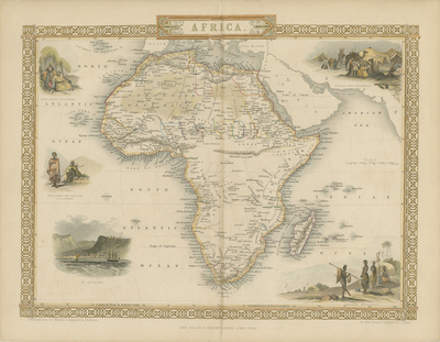
Drawn by J.Rapkin for Montgomery Martin's book "The British Colonies;" Volume IV ("Africa and the West Indies.") At the time the map was produced most of central Africa was still unknown to Europeans. Geographers had no knowledge of Lake Tanganyika and Lake Victoria and still believed that the legendary 'Mountains of the Moon' were the source of the Nile River. The colored map features five vignettes surrounding Africa. Depictions of an Arab family of Algeria, Bosjesman Hottentots (Wild Bushmen), and St. Helena to the left and of the Bedouin Arabs encampment and Korranna Hottentots to the right of the map. Scale in miles is also included to the right. A geometric and decorative border surrounds the map, with title located at top center. Hachures are lightly used to indicate coasts. Double-paged, single-sided, horizontal map. Verso is blank. 27 cm. x 36 cm. [Gift of Dr. Jack Franke]
Archival Date
1851
Collection Name
Maps of Africa
Collection Number
Acc. 2019-231
Language
English
Original Format
Maps
File Format
JPG
Rights
Rights held by The University of Texas at Arlington Libraries, Special Collections. Any use of content downloaded or printed from this page is limited to non-commercial personal or educational use, including fair use as directed by U.S. copyright laws. For more information or for reproduction requests, please contact UTA Special Collections by emailing spcoref@uta.edu.
License

This work is licensed under a Creative Commons Attribution-NonCommercial 4.0 International License
Subjects
Maps; Africa; Lakes; Islands; Mountains; Indigenous peoples; Illustrations; Borders (Ornamental)