


Preview
Identifier
20086406
Description
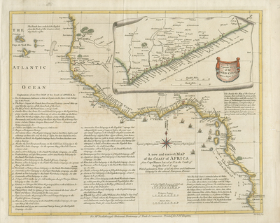
Lightly colored map of the western African coast. Spans from Cape Blanco/Gum coast near Senegal, to the Angola coast. Published in Malachy Postlethweyt's two volume "Dictionary of Trade and Commerce," between 1751 and 1774. A separate map of the Gold Coast provided in top right; an inset within print of continent's mainland, accompanied with separate scale, and engraved by William Seale (modeled after Jean-Baptiste Bourguinon D'Anville). Guinea coast features different commercial interests of European colonials. Senegal is referred to as the Gum Coast, Sierra Leone and Liberia as the grain coast, Ivory coast, Ghana, and Benin, labeled as the Gold Coast; concludes with Loango St. Pauls in Angola. Extensive accompanying text, located below map print, gives detailed explanation of different resources, possessions, references, and routes within selective areas along the western coast. Resources mentioned in map include slaves, ivory, gold, gum and grain. Red flags indicate European settlements and forts. This map provides crucial insight into European interests of commerce and wealth, found and extracted from Africa. Title of map located within Atlantic Ocean, beside the concave shape of continent's landmass, below "Gold Coast." Compass rose available, with small fleur-de-lis motif featured above. Parts of Angola extend beyond border. Surrounding border of map includes scale. Scale key provided beneath title, with three different scale measurements. Locale of various tribes and seasonal climate patterns noted. Landforms and waterways generally located Hachures depicted off coast(s). Single-paged, single-sided, horizontal map on laid paper. Without centrefold or binding. Verso is blank. 43 cm. x 52 cm. [Gift of Dr. Jack Franke]
Archival Date
1755
Collection Name
Maps of Africa
Collection Number
Acc. 2019-211
Language
English
Original Format
Maps
File Format
JPG
Rights
Rights held by The University of Texas at Arlington Libraries, Special Collections. Any use of content downloaded or printed from this page is limited to non-commercial personal or educational use, including fair use as directed by U.S. copyright laws. For more information or for reproduction requests, please contact UTA Special Collections by emailing spcoref@uta.edu.
License

This work is licensed under a Creative Commons Attribution-NonCommercial 4.0 International License
Subjects
Maps; Africa; Slave trade; Waterways; Colonies; Cartouches (Graphic)