


Alternative Title
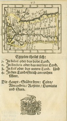
[Egypt may be divided into...]
Preview
Identifier
20086387
Description
This rare, miniature map of Egypt shows the Nile River and Delta with the Red Sea and a portion of the Sinai. The German text below the map reads: "Egypt may be divided into: 1. Sahid or the upper land. 2. In Bechri or the middle land. 3. In Erif or the lower land. and 4. In the strip of land on the Red Sea. The main cities are Cairo, Alexandria, Rosetta, Damiata, and Suez." The map is probably from Johann Ulrich Müller's "Kurtzbündige Abbild und Vorstellung der Gantzen Welt..." (Ulm, 1692). There is a decorative motif of bird and fruit below the text. Single-page, single-sided map with faint yellow outline around Egypt. Uncolored. [Gift of Dr. Jack Franke]
Archival Date
1702
Collection Name
Maps of Africa
Collection Number
Acc. 2019-381
Language
German
Original Format
Maps
File Format
JPG
Rights
Rights held by The University of Texas at Arlington Libraries, Special Collections. Any use of content downloaded or printed from this page is limited to non-commercial personal or educational use, including fair use as directed by U.S. copyright laws. For more information or for reproduction requests, please contact UTA Special Collections by emailing spcoref@uta.edu.
License

This work is licensed under a Creative Commons Attribution-NonCommercial 4.0 International License
Subjects
Maps; Africa; Egypt; Miniature works; Rivers; Illustrations