


Preview
Identifier
20086389
Description
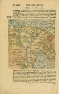
Colored woodblock map of the Nile Delta graphically depicting surrounding sea, rivers, pyramids, sand dunes, and fertile areas. On recto, full sheet of German text with two large woodblock illustrations of a ram (top) and a fountain (below). From Sebastian Münster, Cosmographey oder Breschreibung aller Länder (Basel: Petri, 1588; first published there in 1544). Single paged, double sided. One side with full text and two illustrations of ram and fountain. Verso side has map with text above and below the map. Colored illustrations. 18 cm. x 16 cm. [Gift of Dr. Jack Franke]
Archival Date
1588
Collection Name
Maps of Africa
Collection Number
Acc. 2019-305
Language
German
Original Format
Maps
File Format
JPG
Rights
Rights held by The University of Texas at Arlington Libraries, Special Collections. Any use of content downloaded or printed from this page is limited to non-commercial personal or educational use, including fair use as directed by U.S. copyright laws. For more information or for reproduction requests, please contact UTA Special Collections by emailing spcoref@uta.edu.
License

This work is licensed under a Creative Commons Attribution-NonCommercial 4.0 International License
Subjects
Maps; Africa; Egypt; Rivers; Sand; Dunes; Seas; Illustrations; Woodcuts