


Preview
Identifier
20086386
Description
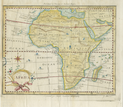
18th century engraved map, produced within the United States. Issued at Boston, 1796. One of relatively few maps created within the country prior to 1800 which depict Africa, the first one only dating 6 years prior to this in 1790. Title at lower left within ornate ribbon & floral cartouche, compass rose above beside the tip of South America along left edge. Colored map. Horizontal, single paged, single sided. Original fold lines as issued. 33 cm. x 21 cm. [Gift of Dr. Jack Franke]
Archival Date
1796
Collection Name
Maps of Africa
Collection Number
Acc. 2019-306
Language
English
Original Format
Maps
File Format
JPG
Rights
Rights held by The University of Texas at Arlington Libraries, Special Collections. Any use of content downloaded or printed from this page is limited to non-commercial personal or educational use, including fair use as directed by U.S. copyright laws. For more information or for reproduction requests, please contact UTA Special Collections by emailing spcoref@uta.edu.
License

This work is licensed under a Creative Commons Attribution-NonCommercial 4.0 International License
Subjects
Maps; Africa; Islands; Cartouches (Graphic)