


Preview
Identifier
20086385
Description
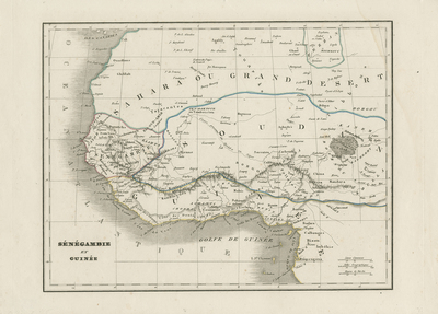
Uncolored map of western Africa coastline, from modern-day western Sahara to The Congo. Regions delineated by colored outlines. Includes depictions of landforms and waterways. Hachures are used to indicate surrounding coastline(s) of continent. Scale of map located at bottom right and title of map located at bottom left. Surrounding border is undecorated, and includes scale. Single-paged, single-sided, horizontal map. 21 cm. x 27 cm. [Gift of Dr. Jack Franke]
Archival Date
1838
Collection Name
Maps of Africa
Collection Number
Acc. 2019-333
Language
French
Original Format
Maps
File Format
JPG
Rights
Rights held by The University of Texas at Arlington Libraries, Special Collections. Any use of content downloaded or printed from this page is limited to non-commercial personal or educational use, including fair use as directed by U.S. copyright laws. For more information or for reproduction requests, please contact UTA Special Collections by emailing spcoref@uta.edu.
License

This work is licensed under a Creative Commons Attribution-NonCommercial 4.0 International License
Subjects
Maps; Africa; Deserts; Guinea