


Preview
Identifier
20086382
Description
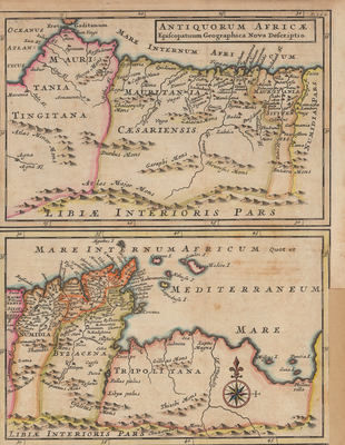
Two maps, of present-day adjacent countries Morocco, Algeria, Tunisia and Libya during ancient times by Herman Moll, from his "Atlas Geographicus." Map above features northwestern coastal counties of the time, such as Mauritania Tingitana, Mauritania Caesariensis, and Numidia. Bottom map depicts countries east of Numidia, like Procosularis, Byzacena, and Tripolitana. Border surrounding maps include scales. Map key is not provided. Title located in top right corner. Includes compass rose within bottom map of Tripolitana, with fleur-de-lis motif pointing north. Regions delineated by colors. Landmarks and waterways located throughout. Hachures depicted off coast(s). Single-paged, single-sided, vertical map on laid paper. Folds as issued. Without binding or single centrefold. Verso is blank. 20 cm. x 28 cm. [Gift of Dr. Jack Franke]
Archival Date
1711
Collection Name
Maps of Africa
Collection Number
Acc. 2019-312
Language
Latin
Original Format
Maps
File Format
JPG
Rights
Rights held by The University of Texas at Arlington Libraries, Special Collections. Any use of content downloaded or printed from this page is limited to non-commercial personal or educational use, including fair use as directed by U.S. copyright laws. For more information or for reproduction requests, please contact UTA Special Collections by emailing spcoref@uta.edu.
License

This work is licensed under a Creative Commons Attribution-NonCommercial 4.0 International License
Subjects
Maps; Africa; Morocco; Tunisia; Algeria; Libya; Waterways; Mountains