


Alternative Title
Africa; a Map of Zaara, Negroe-land, Guinea &c.
Preview
Identifier
20086381
Description
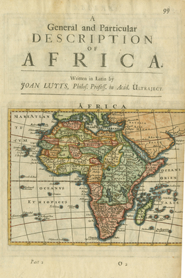
Cover page with map of Africa by Herman Moll from a particular section of Herman Moll's "A System of Geography: or, a New & Accurate Description of the Earth in all its Empires, Kingdoms and States," published in London by Moll in 1701. At top of sheet: "A General and Particular Description of Africa. Written in Latin by Joan Luyts, philos. Profess. in Acad. Ultraject." "Part 2 O2." On verso: "Barbary and Bildulgerid, A map of Zaara, Negroe-land, Guinea &c. /H. Moll fecit," with inset: "The Isles of C, Verd." Double-sided, single paged, with modern notes along bottom edge. Vibrantly colored cover page. 31 cm. x 21 cm. [Gift of Dr. Jack Franke]
Archival Date
1701
Collection Name
Maps of Africa
Collection Number
Acc. 2019-237
Language
English;Latin
Original Format
Maps
File Format
JPG
Rights
Rights held by The University of Texas at Arlington Libraries, Special Collections. Any use of content downloaded or printed from this page is limited to non-commercial personal or educational use, including fair use as directed by U.S. copyright laws. For more information or for reproduction requests, please contact UTA Special Collections by emailing spcoref@uta.edu.
License

This work is licensed under a Creative Commons Attribution-NonCommercial 4.0 International License
Subjects
Maps; Africa; Vignettes; Islands; Title pages; Guinea; Deserts; Geography