


Preview
Identifier
metapth220355
Description
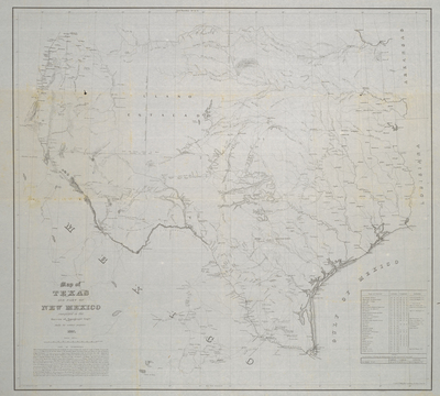
The U.S. War Department published this highly detailed map of Texas in limited numbers “chiefly for military purposes” in 1857. It shows trails, roads, forts, and topographical details such as water sources, hills, ridges, and mountains. The map was compiled from recent and older Army explorations and surveys, most of which were conducted by officers of the Army’s Bureau of Topographical Engineers. These “authorities” are listed at lower left and their routes and trails are noted on the map itself. Some of the most recent included “Military Surveys and Reconnaissances” by Lieutenant Colonel Joseph E. Johnston, Topographical Engineers Lieutenants F. T. Bryan, Martin L. Smith, W. F. Smith, and Nathaniel Michler “up to 1851” (thus incorporating information from their newer work produced after the printed map of 1849/1850, cat. no. 59), Major Willam H. Emory’s “Map of the Rio del Norte Section…” of the U.S. Mexico-Boundary survey (1857), Lieutenant Amiel W. Whipple’s U.S. Pacific Railroad Survey “up to 1856,” Lieutenant J. N. Moore’s map of a portion of New Mexico (1857), and Captain Randolph B. Marcy’s maps for his exploration of the Red River (1852). Many of the soldier’s trails, paths, and roads connected newly established forts in west and south Texas (Forts or Camps Mason, Belknap, Phantom Hill, Chadbourne, Concho, McKavett, Terrett, Clarke, Duncan, and Hudson), eastern New Mexico (Forts Stanton, Craig, and Thorn), as well as older forts in Texas and Indian Territory. The Topographical Engineers compiling the map also incorporated information from the U.S. Army’s surveys made during the U.S. War with Mexico of 1846-1848 and for the earlier U.S. boundary with the Republic of Texas (1840) as well as sketches for the U.S. Coast Survey (1850s) and DeCordova’s (and Creuzbauer’s) map of Texas based upon surveys for the Texas General Land Office (1849, cat. no. 58, and later editions). This formidable list of sources together with more accurate geodetic coordinate readings, listed along with the “authorities” or officers that took those measurements in a table at lower right, meant that for the first time the shape of Texas boundaries appear fully comparable with those commonly recognized today.
Archival Date
1857
Location
103/4
Collection Name
Cartographic Connections
Collection Number
2005-1338
Publisher
University of Texas at Arlington Libraries
Original Format
Map
File Format
JPG
Rights
Any use of content downloaded or printed from this site is limited to non-commercial personal or educational use, including fair use as directed by U.S. copyright laws. For more information or for reproduction requests, please contact Special Collections
Subjects
Texas; Mexico
Item Type
image
Names
U.S. Army Topographical Engineers
Subjects
Texas; Mexico