


Preview
Identifier
metapth193691
Description
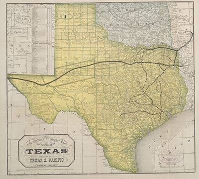
This map was widely distributed, and it reveals the role of railroads in the state’s development. The map was produced by the Texas & Pacific Railway, which was one of the most ambitious of the numerous railroads that flourished in post-Civil War Texas. Established by a federal charter in 1871, the Texas & Pacific was granted permission to build a southern transcontinental railroad from Marshall, Texas, to San Diego, California. By 1873, the Texas & Pacific Railway ran from Texarkana to Dallas, and by 1876 a second line of the Texas & Pacific Railway connected Texarkana and Sherman. Building westward from Dallas, the railroad reached Fort Worth, in July of 1876. At the time this map was prepared, the Texas & Pacific Railway was anticipating opening up west Texas to development
Archival Date
1878
Location
82/4
Collection Name
Cartographic Connections
Collection Number
90-330
Publisher
University of Texas at Arlington Libraries
Original Format
Map
File Format
JPG
Rights
Any use of content downloaded or printed from this site is limited to non-commercial personal or educational use, including fair use as directed by U.S. copyright laws. For more information or for reproduction requests, please contact Special Collections
Subjects
Texas
Item Type
image
Names
The Texas and Pacfic Railway
Subjects
Texas