


Preview
Identifier
metapth192535
Description
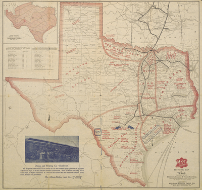
The Missouri, Kansas, and Texas Railway (also known as the “Katy” Railroad) created this cerographic, two-color map in 1904 as a promotion for its rail service throughout the region. Note that this map was provided with the compliments of the Allison-Richey Land Company, which has hand-stamped the map showing areas currently ready for settlement in southern and southeast Texas. This suggests a close working relationship between the railroad company and the land company. In the map’s lower left hand corner, a promotional picture shows well-to-do prospective settlers in front of the railroad’s dining and sleeping cars, presumably well-rested and ready to start new lives on land of their own. It should also be noted that the picture appears to have been printed over the portion of the map showing Mexico, and that map details can still be seen under the ink from the picture.
Archival Date
1904
Location
26/3
Collection Name
Cartographic Connections
Collection Number
310014
Publisher
University of Texas at Arlington Libraries
Original Format
Map
File Format
JPG
Rights
Any use of content downloaded or printed from this site is limited to non-commercial personal or educational use, including fair use as directed by U.S. copyright laws. For more information or for reproduction requests, please contact Special Collections
Subjects
Texas
Item Type
image
Subjects
Texas