


Preview
Identifier
metapth192781
Description
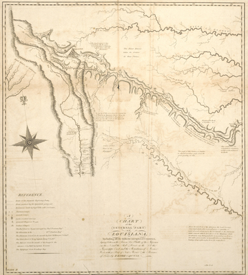
Zebulon Pike and his men were among the first foreigners to visit the Spanish Borderlands. His two maps, as printed by Anthony Nau and possibly Nicholas King, represent an improvement in the geographical knowledge of the area, but they are far from satisfactory as Pike had little scientific training and had worked under terrible conditions. He apparently mistook the Canadian fork of the Arkansas River for the Red River and became lost in the maze of mountains in present central Colorado. His route along the upper Arkansas and a portion of the Rocky Mountains of Colorado as well as the route taken by his Spanish captors (who also confiscated his field map) appear on this map from the 1810 edition of his account. Pike’s “Highest Peak” – later renamed for the explorer by his companion Dr. Robinson – is in the upper-left portion of the map. The map was overly simplified, and, by placing the “Yellow Stone River, Branch of the Missouri,” “La Platte,” and “Sources of the Arkansaw” [sic] in the upper-left corner, it perpetuated a mistaken geographical theory that all the rivers flowing east to the Mississippi and west to the Pacific originated from a small area in the Rockies. [Gift of Jenkins Garrett]
Archival Date
1810
Location
53/7
Collection Name
Cartographic Connections
Collection Number
90-759
Publisher
University of Texas at Arlington Libraries
Original Format
Map
File Format
JPG
Rights
Any use of content downloaded or printed from this site is limited to non-commercial personal or educational use, including fair use as directed by U.S. copyright laws. For more information or for reproduction requests, please contact Special Collections
Subjects
Louisiana
Item Type
image
Names
Pike, Zebulon Montgomery (1779-1813); Nau, Anthony
Subjects
Louisiana