


Preview
Identifier
metapth192567
Description
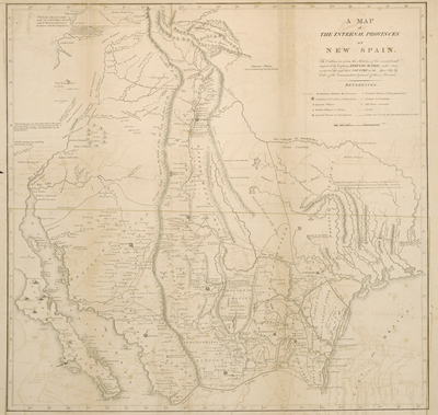
Zebulon Montgomery Pike was twenty-seven years old when he set out on an expedition in July 1806 to explore the headwaters of the Arkansas and Red rivers. A lieutenant in the U.S. Army, Pike had been ordered on the expedition by Gen. James Wilkinson, then military governor of the Louisiana Territory. The Louisiana Territory had recently been purchased from France in 1803 but Spain disputed U.S. president Thomas Jefferson’s belief that the western boundary of the newly purchased land was the Rio Grande. To enable the U.S. to have a better understanding of the western and southwestern part of the Louisiana purchase Pike and party left St. Louis, Missouri Territory, in the summer of 1806. They proceeded overland to the Arkansas River, where a small party under Gen. Wilkinson’s son, Lt. James Wilkinson, was dispatched to follow the river to its mouth. Pike and the remains of the party continued up the Arkansas River to the vicinity of presentday Pueblo, Colorado, and the mountains that now bears his name (Pike Peak). There they moved west to the Rio Grande, where they were captured by Spanish troops and escorted south into Chihuahua, a town in New Spain. In Chihuahua, Pike was quartered with Juan Pedro Walker, a Louisiana born engineer in the Spanish Army. Pike’s papers were confiscated, and he and his men eventually were marched east across Texas by way of the Old San Antonio Road to Natchitoches apart of the U.S. In 1810 Pike published an account of his adventures entitled An Account of Expeditions to the Source of the Mississippi and Through the Western Parts of Louisiana, to the sources of the Arkansas, Kans, La Platte, and Pierre Juan Rivers. Philadelphia: C. & A. Conrad & Co., 1810. This map was one of the several included in his book. Pike’s map actually created something of a stir upon publication, when Baron Alexander von Humboldt claimed publicly that Pike’s map was a direct copy of a draft of his own map that he had left in Washington, D.C., in 1804. There is little doubt that Pike had been given access to Humboldt’s manuscript map, and that it likely influenced Pike’s map to some extent. However, Pike’s map is not an exact copy. In fact, when comparing the depiction of Texas on both maps, there are many differences, including the drawing of the coastline, the course of the rivers, and the location of Spanish settlements. Overall, Pike’s depiction of Texas is more accurate than Humboldt’s, no doubt a result of Pike’s firsthand observations and information he had gained from Juan Pedro Walker. Pike’s book and map, published four years before the journal of Lewis and Clark, gave the American public its first glimpse of the land west of the Mississippi River. [Gift of Jenkins Garrett]
Archival Date
1810
Location
27/9
Collection Name
Cartographic Connections
Collection Number
310162
Publisher
University of Texas at Arlington Libraries
Original Format
Map
File Format
JPG
Rights
Any use of content downloaded or printed from this site is limited to non-commercial personal or educational use, including fair use as directed by U.S. copyright laws. For more information or for reproduction requests, please contact Special Collections
Subjects
New Spain
Item Type
image
Names
Zebulon Pike (1779-1813)
Subjects
New Spain