


Preview
Identifier
metapth187679
Description
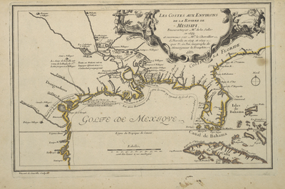
De Fer’s deceptively simple map of 1701 was a major improvement over earlier printed maps of the Gulf coast area. It incorporated much new information from the recent 1698 and 1699 French expeditions of Pierre le Moyne, Sieur d’Iberville, and his brother Jean Baptiste, and it emphasized the earlier explorations of La Salle. Importantly, it drew upon a new placement of the Mississippi credited to the gifted young geographe Guillaume Delisle before he had been able to publish his own detailed map of the area. Political sensitivies probably had prevented Delisle from including information about d’Iberville’s explorations on his 1700 map of North America because the French were in the middle of negotiations with the Spanish over Louis XIV’s grandson Philippe, duc d’Anjou’s succession to the Spanish throne as Felipe V. The French had not wanted to upset the Spanish any further with news of d’Iberville’s activities in their claimed territories until the uncertainty was over. By 1701, this mattered less. De Fer’s engraver Vincent de Ginville includied interesting vignettes of La Salle’s tragic murder and that of his assassin in the cartouche, which tend to draw the viewer’s attention away from the map itself. Like his competitors the Delisles, who at this time were also studying manuscript maps from the French expedtions as well as copies of earlier Spanish maps, De Fer now placed the Mississippi entering the Gulf in a location east of present Texas and created a much better defined coast. Not only does de Fer show an approximate location for La Salle’s failed fort near Matagorda Bay, there are also forts in the area around what should be Lakes Pontchartrain and Bourne. De Fer’s Spanish sources probably also included the Abbé Bernou’s copy of Carlos de Sigüenz y Gongora’s map of 1689 which showed the route of Alonso de León’s expedition to find La Salle and Juan Bisente del Campo’s copy of Spanish mapping efforts along the coast by Juan Enríquez Barroto. The French had found Bisente’s chart along with two French survivors of La Salle’s expedition in 1697, when they captured a Spanish ship. Before de Fer produced this map, he had published a large wall map in 1698 that followed Coronelli’s model of the area in showing the Mississippi entering the Gulf in Texas.
Archival Date
1701
Location
20/1
Collection Name
Cartographic Connections
Collection Number
900017
Publisher
University of Texas at Arlington Libraries
Original Format
Map
File Format
JPG
Rights
Any use of content downloaded or printed from this site is limited to non-commercial personal or educational use, including fair use as directed by U.S. copyright laws. For more information or for reproduction requests, please contact Special Collections
Subjects
Florida; Cuba; Gulf of Mexico
Item Type
image
Names
de Fer, Nicolas (1646-1720)
Subjects
Florida; Cuba; Gulf of Mexico