


Preview
Identifier
metapth190463
Description
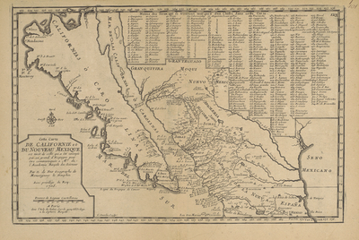
The map’s title translates roughly “This map of California and New Mexico is taken from one that was sent by an important Spaniard to be communicated to members of the Royal Academy of Sciences.” The manuscript map in question was a copy of a 1695-1696 map drawn by the Jesuit priest and missionary Father Eusebio Kino, who, by that time had traveled over much of northern New Spain yet still believed that California was an island. Kino’s map had a great deal of new and reliable information about Spanish missions and settlements, including sites along the upper reaches of the Rio Grande in present Chihuahua and far west Texas. As noted in Fer’s title, a Spanish nobleman forwarded a copy of Kino’s 1695-1696 map to the French Royal Academy of Sciences where in 1700 de Fer and engraver Charles Inselin copied it without crediting Kino. De Fer and Inselin rearranged Kino’s map with a numbering system and keyed list and, in so doing, failed to transfer all the sites and names with complete accuracy. Although de Fer’s map was an improvement for its time, the map was quickly superseded by other printed maps based on a more famous 1701 manuscript map by Kino that showed California as a peninsula.
Archival Date
1705
Location
64/7
Collection Name
Cartographic Connections
Collection Number
2007-359
Publisher
University of Texas at Arlington Libraries
Original Format
Map
File Format
JPG
Rights
Any use of content downloaded or printed from this site is limited to non-commercial personal or educational use, including fair use as directed by U.S. copyright laws. For more information or for reproduction requests, please contact Special Collections
Subjects
California; New Mexico
Item Type
image
Names
de Fer, Nicolas (1646-1720)
Subjects
California; New Mexico