


Preview
Identifier
metapth298888
Description
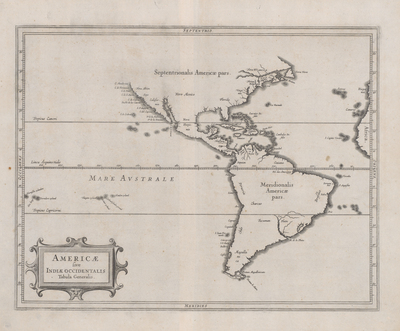
This general map of the American continent was produced by geographer and Dutch West India Company (WIC) director Johannes de Laet (1593-1649) and Hessel Gerritsz (1580-1632) who, until his death, was the official cartographer for the Dutch East India Company (VOC, from 1617) and for the WIC (beginning in 1621). Like other maps in various editions of Laet’s book on the Americas, it departs from the more decorated styles of maps common at the time to concentrate upon as much accurate, verifiable information as possible. Due to a lack of reliable information the cartographers did not show a northwest passage or even a northwest coast, and, despite recent and contemporary maps that showed California as an island, they did not succumb to this delusion either.
Archival Date
1630
Location
25/8
Collection Name
Cartographic Connections
Collection Number
88-154
Publisher
University of Texas at Arlington Libraries
Original Format
Map
File Format
JPG
Rights
Any use of content downloaded or printed from this site is limited to non-commercial personal or educational use, including fair use as directed by U.S. copyright laws. For more information or for reproduction requests, please contact Special Collections
Subjects
South America; Mexico; Cuba; Africa
Item Type
image
Names
Laet, Johannes de (1593-1649); Gerritsz, Hessel (1580-1632)
Subjects
South America; Mexico; Cuba; Africa